
NWS severe thunderstorm watch active across multiple US states. 2026 is breaking storm records. What it means, who’s at risk, and how to stay safe now.
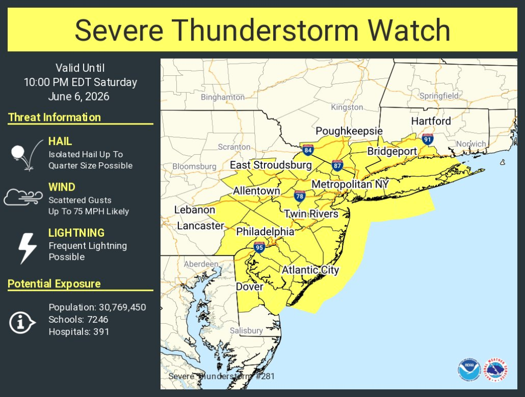
Table of Contents
Severe Thunderstorm Watch Issued Across Multiple US States — 2026 Is Breaking Records and the Season Isn’t Done
Phillipsburg, New Jersey went dark Saturday evening.
A utility pole came down. Emergency crews blocked off the road — live wires on the ground. Over 800 homes and businesses lost power in one neighbourhood alone, all within minutes of the storm hitting. This wasn’t some freak isolated event. It happened the same night the National Weather Service issued a severe thunderstorm watch covering every single one of New Jersey’s 21 counties — high winds, large hail, torrential rain, isolated tornado potential, the whole picture.
That was June 6. The Storm Prediction Center’s outlook for June 7 is still flagging severe thunderstorm threats across the Northern Plains — large hail and damaging winds over the Dakotas and Wyoming, tornado risk stretching from eastern Oklahoma across the Ozarks. The system is still moving.
This is what a busy severe weather season looks like mid-stream.
➛ For More Updates Visit NewzByte
The Season Context — And Why 2026 Feels Different
Look at the numbers the NWS Chicago office published through mid-April and they’re hard to ignore. Eleven individual severe weather events from January 1 through April 19 — the long-term average for that same window is roughly four. They issued 128 severe thunderstorm and tornado warnings through April 19, which their own office described as a record high for that date.
Eight severe thunderstorm watches, six tornado watches — 14 convective watches total — in the Chicago forecast area alone before peak season had even properly opened. At least 20 confirmed tornadoes in that same zone.
The Storm Prediction Center had issued outlooks for severe weather across the Chicago region on 15 days in 2026, including an unusual number at Enhanced risk or higher. Normally that’s 4 to 8 days through the end of April.
One event in March showed how extreme things got. A supercell on March 10 produced a hailstone near Kankakee measuring 6.14 inches in diameter — a potential Illinois state record, shattering the previous mark of 4.75 inches. The Storm Prediction Center had flagged moderate risk for severe weather that day, including very large hail and intense tornadoes. They were right.
AccuWeather’s seasonal forecast called for 1,050 to 1,250 tornadoes across the US in 2026. Meteorologist Alex Duffus noted fewer tornadoes might form than last year but emphasized the bigger concern this season is damaging wind gusts and heavy downpours — and that flash flooding in particular is a significant threat. The point he made that stuck — it only takes one storm hitting a populated area at the wrong moment.
What a Severe Thunderstorm Watch Actually Is — And Why People Get It Wrong
Here’s where most public understanding breaks down. A watch and a warning are not the same level of urgency, but they’re not as different as people assume either.
A severe thunderstorm watch means the atmosphere is primed. Conditions exist for severe storms to develop in the area — not confirmed yet, but possible, sometimes likely. The National Weather Service issues watches to give people time — time to secure outdoor furniture, time to find shelter options, time to charge a phone and figure out where you’ll go.
A warning means it’s already happening or about to. Radar has detected it, or a trained spotter has confirmed it on the ground. That’s the signal to take cover immediately — interior room, lowest floor, away from windows. Not to finish what you’re doing first.
The error most people make is treating a watch like background noise and waiting for a warning to act. By warning time, the storm is often minutes away. There isn’t always time to gather children, move cars, or find the safest room if you haven’t already thought about it.
The NWS recommends staying inside for at least 30 minutes after the last thunder clap — lightning can still strike when a storm appears to be passing. That guidance gets ignored constantly.
What the Storms Themselves Do
Officially, a severe thunderstorm means one of three things: hail at least one inch in diameter, wind gusts at 58 mph or stronger, or a tornado. Those are the NOAA thresholds. In practice — and the events of the past week demonstrate this — severe storms often hit multiple criteria at once.
Wind at 60 mph brings down trees and utility poles. The New York City region saw gusts exceeding that on June 6, with numerous downed trees reported across the metro area. Quarter-size hail was confirmed in Ohio counties during a Pittsburgh NWS warning issued the same evening. In Oklahoma, a storm near Davis was moving northeast at 20 mph with 60 mph gusts — the NWS Norman office warned of damage to roofs, siding and trees.
Flash flooding sits in a separate category of danger because it’s not what most people picture when they think of a thunderstorm threat. Six inches of moving water is enough to knock an adult off their feet. One foot can carry a vehicle away — including a full-size car or truck. The majority of flood deaths in the US happen in or near vehicles, often on roads that looked passable from a distance. NWS guidance on this is consistent and unambiguous: do not drive through water on the road.
Lightning travels further than storms appear to. It can strike up to 10 miles ahead of or behind a visible storm system. If you can hear thunder, you’re within range — the National Weather Service is direct about this. Go inside.
Who Gets Caught Out — And Why
There are a few patterns that show up in severe storm injury and fatality data repeatedly.
People sheltering under park pavilions, bleachers, or isolated gazebos during storms. The NWS warns specifically against this — those structures are often the highest point in an open area, which makes them targets. A pavilion roof offers zero meaningful protection from large hail and lightning, and is vulnerable to wind damage.
Convertible cars, motorcycles, open vehicles. A metal-roofed hardtop provides some protection from lightning because the body channels electricity around the occupants. Convertibles, motorcycles, open trailers — none of that applies.
People who go back outside too soon. The 30-minute post-thunder rule exists because dissipating storms still carry lightning risk. Downed power lines discovered after a storm look inactive and often aren’t — the ground around them can be electrified several feet in every direction.
Generators brought indoors or into garages. This produces carbon monoxide. Every single year, people die from this after storms. The generator goes outside, positioned away from windows and doors — nowhere else.
What to Do Right Now If a Watch Is in Your Area
Charge your phone before the storm arrives, not during. Power outages in severe thunderstorm events are common, sometimes lasting hours.
Bring in or secure anything outside — furniture, potted plants, trash cans, anything that could move in 60 mph wind. Not because those items are expensive, but because they become projectiles.
Identify where you’ll shelter before you need to. Interior room, lowest floor, away from exterior walls and windows. In a house that’s a bathroom, closet, or central hallway. In an apartment building, a ground-floor or basement corridor. Know the answer in advance.
Move the car to a garage if possible. Hail damage from one storm can run into thousands in repairs. When a garage isn’t available, a covered parking structure is better than an open lot.
Keep a battery-powered radio available. When power goes out and cell towers get congested with traffic, a $30 weather radio picks up NWS continuous broadcasts without needing either.
After the storm — avoid downed lines, avoid flooding roads, and don’t run generators or gas grills indoors under any circumstances.
Where to Track Active Watches
weather.gov — National Weather Service. Search by county. Shows every active watch, warning and advisory in real time, free.
spc.noaa.gov — Storm Prediction Center. Single map showing all active severe thunderstorm and tornado watches across the country, updated continuously.
Wireless Emergency Alerts — your phone gets these automatically for warnings when you’re in the affected area. Watches don’t always trigger phone alerts — monitor weather.gov manually during active watch periods.
One More Thing Worth Saying
The June 6 storms hit New Jersey fast. The warning in Phillipsburg came at 6:13 PM — the storm followed almost immediately. The window between watch and warning in a fast-moving system can be very short. That’s not an argument for panic. It’s an argument for doing the preparation during the watch so that when the warning drops, there’s nothing left to figure out.
The 2026 season has been running well ahead of historical averages since January. The Northern Plains and Midwest are still active as of today. Anyone in a watch area this week should take it at face value — the NWS data from this season alone gives you every reason to.
Sources: National Weather Service (weather.gov) | Storm Prediction Center (spc.noaa.gov) | AccuWeather | NOAA